
January 14th, 2015
Bear Mountain has been present to me ever since my first kayak on Newfound Lake. It is the main focal point from the East side of the lake as it sticks out in the ridge line. I was looking around for something new to do, to expand on my selection of short hikes nearby, and Bear seemed to fit the bill.
The only problem was that I couldn’t seem to find any info on it! Usually there’s at least a little bit of trail info on conservation association websites, but the little I found was from the Forest Service Maps and AllTrails.com, neither of which gave me a whole lot of confidence about where I was going.

This may or may not come as a shock to some people, but I’m relatively cautious about my outdoor adventures. I like to have an idea of what I’m getting myself into before I go. The info on this hike is sparse, and the reality is somewhat confusing. There are two Bear Mountain trail heads. One is very, very close to the Hebron town common and was established by the Audubon society that lives down the road. This trail lies on a newly conserved piece of land, and from what I could tell when I explored it for the first time, does NOT lead to the top of Bear Mountain.

To get to the Bear Mtn Trail that actually leads to the top of Bear Mountain, one must travel further down West Shore Road to Bear Mountain Road on the right. The road then forks with Panorama Ln, but hikers should head strait and then IMMEDIATELY PARK BECAUSE THE ROAD IS NOT ACTUALLY A ROAD AND YOU MIGHT BECOME TRAPPED.
All drama aside, I grabbed Eric again for this hike, and started at the fork of Bear Mtn. Rd. and Panorama Ln. To add to the confusion, there don’t seem to be any proper maps handy, so I will rough out a picture of what the trail looks like:

So. Basically a hiker must walk up the rest of Bear Mtn “road,” (actually renamed Hebron “Road” at this point), which is really just a wide dirt trail. It became apparent to me after we had walked about a quarter mile just why this trail seems to have fallen into obscurity. The whole swathe of land around the road/trail has been almost completely cleared of trees. It looks like a bloody war zone, the collateral damage of the boom and bust realty market of the past five years; like a developer came in, all positive that they were going to sell the crap out of the lake view land, and then just couldn’t. What is left is an area devoid of trees, littered with boulders, and ripe for some springtime erosion.

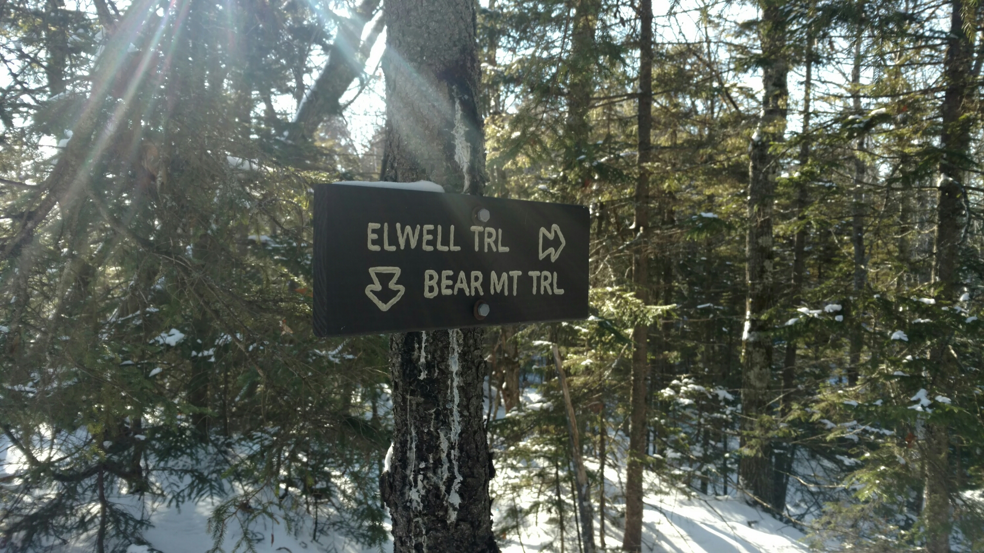
We walked uphill through all this clearing until we spotted the hard right turn marked by a sign leading us to the Bear Mt. Trail. This hike became even more bizarre when we had to meander our way through all the clear-cut roughage in order to follow the trail. Seemingly miraculously, there were still blazes guiding our way.

This trail is no joke. It’s short but extremely steep. Once we got back into the woods, it was basically straight up the side until we reached the ridge line. Then began my history lesson.
Eric had already been doing research about the seemingly endless number of hidden trails that cover New Hampshire like mycelia in the forest. It turns out that the Bear Mtn. trail connects with the the long-standing Elwell trail that runs from the Sugarloaf Mtns. at Wellington State Park all the way down and around to Mt. Cardigan.
The trail was cut by Camp Mowglis and anyone wanting more info about the trail should check out this cool blog post here.
I am so into the idea of doing this trail as a little through hike now that I know about it.
As for Bear Mt. and the Bear Mt. trail, it seems to be a bit of a lost legacy, a trail that hasn’t gotten much attention and may or may not run through private land. I’ve added it to my list of hikes under the category “Hikes That Will Kick Your Ass But Are Short And Don’t Give A Clear View But Are Still Really Cool For Some Reason.”

Cheers!
Molly

3 responses to “Bear Mountain: A Forgotten Legacy?”
Thanks, Molly! We had tried to find the summit of Bear as well both from the Elwell and the route you took. We missed the hard right turn! Will have to try it again. But the devastation that you mentioned was not caused by the real estate market but rather by loggers! Unfortunately, they removed trees with blazes on them, so we could not follow the trail. We did make it back to Goose Pond but with great difficulty. Thank you for your detailed account.
LikeLike
Thanks for your comment! When O did the trail I was able to find some blazes, so definitely try it out again. It’s unfortunate to me that clear cut logging practices are still around in NH especially when there are widely used alternatives regularly practiced by the forest service. In any case, the cleared land is for sale, so I assumed. Thanks for the info.
LikeLike
This was fun and interesting. LLOOVVEE Madre
LikeLike